|
|
|||||||||||||||
|
site plan available lots area information contact us home |
|||||||||||||||
|
area information
|
|||||||||||||||
|
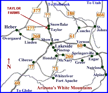
taylor is located in eastern arizona, navajo county and sits at an elevation of 5,640 feet. resting on the banks of silver creek, taylor sits in a broad, flat valley with the mogollon rim and white mountains to the south and west. the mountains form an almost continuous barrier protecting taylor from severe winters and creating a semi-arid climate. taylor farms is located within walking distance of the apache-sitgreaves national forest and permanent access to these public lands is readily available for horseback riding, hiking, biking or exploring! the town is located on state highway 77, south of holbrook and just a few miles south of snowflake. taylor is 189 miles from phoenix and 208 miles from tucson. the taylor airport has a 7,200 foot runway. weather
|
click here for vicinity map close-up
� snowflake/taylor
chamber of commerce
|
||||||||||||||